Severn Partnership Land Survey and 3D laser scanning blog

Blog Pages

  • Home
  • Our projects map
  • Image Gallery
  • Contact Us

Wednesday, 11 February 2009

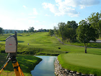
Scanning Valhalla !

Mark Combes and Rollo Rigby on a trip to Kentucky USA to laser scan the greens at the Ryder Cup course. Long days hot days (and nights) to get the job done and produce a fantastic data set. Also, coordinating photocontrol points for aerial mapping. Don't mention that the Americans ended up winning the Ryder Cup.
Posted by Nick Blenkarn at 15:41
Labels: 3D laser scanning, Golf, Kentucky
Newer Post Older Post Home

Website links

  • Severn Partnership Homepage
  • Our 3D modelling website
  • Flickr photos & videos
  • Twitter page
  • Facebook page

Subscribe To

Posts
Atom
Posts
Comments
Atom
Comments

Blog Archive

  • ►  2012 (10)
    • ►  April (1)
    • ►  March (4)
    • ►  February (2)
    • ►  January (3)
  • ►  2011 (34)
    • ►  December (6)
    • ►  November (3)
    • ►  October (1)
    • ►  September (1)
    • ►  August (2)
    • ►  May (9)
    • ►  April (2)
    • ►  March (1)
    • ►  February (9)
  • ►  2010 (12)
    • ►  September (4)
    • ►  June (4)
    • ►  May (3)
    • ►  January (1)
  • ▼  2009 (22)
    • ►  October (3)
    • ►  September (6)
    • ►  June (2)
    • ►  April (1)
    • ►  March (3)
    • ▼  February (7)
      • Surveying slight deviations in cant
      • Coordinating video projection for Alicia Keys...
      • Scanning Valhalla !
      • High accuracy control survey - Rail
      • Laser scanning on the English Riviera
      • 3D laser scanning - Viaduct in Newcastle
      • Severn Partnership Blog updates...... projects ong...

Contributors

  • John Pike
  • Mark King
  • Matt Levine
  • Nick Blenkarn
  • Unknown

Search This Blog

Awesome Inc. theme. Powered by Blogger.