Tuesday 22 February 2011

Scanning & Modelling the Severn Seas...

3D Model of CS Sovereign
Severn Partnership has been laser scanning cable laying ships around the world for Global Marine Systems (GMS). This included GMS's flagship the 'CS Sovereign' as well as the world’s largest cable laying ship; the ‘Cable Innovator’ which was based in Hong Kong at the time.
 
The completed point cloud was then used to create 3D models for integration within GMS’s new 3D navigation system. These models were textured using a single image to give them a more realistic look, similar to the techniques used in the Game Industry (see above image). 

Or call Mark King (3D Modelling & Visualisation) on 0844 880 8247

Saturday 12 February 2011

Can't survey the wood for the trees - Surveys for Forestry Commission

3D landscape visualisation

Severn Partnership in conjunction with Parsons Brickerhoff in Cardiff have been selected for a framework contract with the Forestry Commission Wales.

Our surveyors will create 3D topographical surveys for use in in haul road design and cut & fill volume computations for subsequent earthworks.

We will be able to utilise the latest one man robotic total stations in conjunction with Leica's Smartnet RTK GPS to aid productivity and accuracy.

Contact Nick blenkarn or Bob Hutchings for any topographical survey requirements

Contact Us

Friday 11 February 2011

3D modelling for Acoustic analysis - Dublin Cathedrals

3D watertight model
3D model for acoustic modelling
St Patricks Cathedral


Severn Partnership's 3D modeller Mark King was commissioned by University College Dublin to create 3D models from laser scanned point clouds.

The resultant 'water tight' 3D models were used for acoustic modelling - follow the link below for a sample 3D PDF of St Patrick's Cathedral.

 Click here for a 3D PDF example - acoustic modelling


Call Mark King on 08448808247

Contact Us

Thursday 10 February 2011

Climbing the walls trying to find a 3D survey solution....


3D laser scanning - Leica C10
3D point cloud from laser scanner

Severn Partnership's 3D laser scanner was called in by ZigZag climbing walls to survey an existing Climbing wall in Cambridge, prior to enable design and ensure it fits first time !
The point cloud is an ideal solution for surveying and modelling of obtuse and irregular surfaces.

The survey was completed within an hour on site and a meshed model delivered for design.

For more information, call Mark King (3D modelling & Visualisation) on 08448808247

Wednesday 9 February 2011

Flickr Photostream update

We have updated our flickr photstream with survey images from 2011, CAD screenshots, 3D laser scanning and modelling projects....

Find it at:
Flickr
or
Facebook

Ship deck scanning for 3D modelling - Sunderland

Tuesday 8 February 2011

Real time monitoring for track movement 24/7

Severn Partnership was approached by Alun Griffiths (Contractors) Ltd. to offer a
proposal for the monitoring of rails, for movement, during the piling works for a new footbridge adjacent to the railway fence-line.

The proposal needed to adhere to Network Rail Standard NR/BS/LI/045 ‘Monitoring track over or adjacent to Civil Engineering works: procedure and intervention levels.’

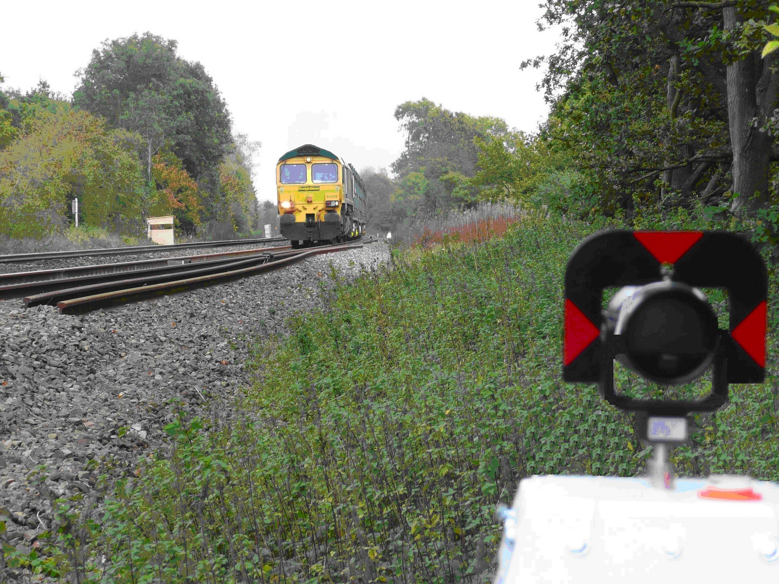
The extent of the monitoring, covered 90m of track length over four rails, with prisms located at 3m centres (124 prisms in total).  Readings being taken 24 hours a day, 7 days a week - feeding back data over an Internet link to our office.

Benefits of Automated technique:
  • Minimised on site manpower (security guard only required)
  • Cheaper overall than manned monitoring
  • Real time results, with reports on twist, CANT, gauge & movement
  • Client reports on demand
  • Piece of mind !
24/7 observations - unmanned
3d monitoring control station


Call Nick Blenkarn or Bob Hutchings at Severn Partnership to discuss your track monitoring requirements.

Contact Us

Monday 7 February 2011

Our projects map

Have a look at our projects map - detailing some of the locations we have worked over the last few years.  Watch out for a Severn Partnership team near you !

Our Projects map


View SP Project Database in a larger map

Sunday 6 February 2011

Surveyors try out life on the front line (of education)...

Under the Young Enterprise scheme Severn Partnership sent 8 Surveyors to deliver 4 modules to the children at Cleobury Mortimer Primary School Shropshire. The Surveyors split into pairs to deliver to 4 classes and a total of 120 children age ranges from 5 to 11 years.

Young Enterprise is a charity which gets businesses into school to educate pupils about work and to equip young people to succeed through enterprise and to get a job when they leave education.

Severn Partnership has been involved for 7 years and had a great day at Cleobury Mortimer School where they taught the children for the whole day. The children enjoyed hearing about the surveying industry as well as a lot more interactive sessions on work in general from the home to community, the UK and even international trade.

The children and teachers were fantastic and great for the Surveyors to work in a new environment, a challenge in itself for them which helps the wider development of the Severn Partnership.

Link to Young Enterprise article....

Tuesday 1 February 2011

Railway Track survey and GPS Control - A frosty start to 2011

Severn Partnership has had to come out “the blocks” at an electrifying pace in 2011 with over 70 miles of mainline railway already surveyed.

Railway surveyors on track in the snow

Railway Track surveys included:

  • St. Pancras to Sheffield  – Midland Mainline over 48 Miles of track surveyed making also making use of the GRP5000 kinematic laser scanning system wit the latest clearoute software from Amberg Technologies.
  • Walsall to Rugeley Trent Valley – RRN – 12 Miles of railway track including fence to boundary fence for the West Midlands Signalling Renewals.

Quality survey data is being delivered to the clients using Severn Partnership’s experienced railway surveyors who are all PTS qualified with Senior Surveyors being COSS qualified.

Large scale geodetic networks are observed using upto 16 number GPS units, simultaneously at times. This is backed up by bespoke Railgrid software experience in which has been gathered over the last 7 years and the commissioning of 9 Railgrid mapping projections including the MM07 Snakegrid for Midland Mainline in 2007.

The Rail Engineer article on St Pancras to Sheffield Geodetic control survey


Contact Us with to talk through your railway survey requirements